The future link between Alaska and Siberia - a transcontinental railway shaping the 21st century:
InterBering Library - News, Studies & Research
BERING STRAIT TUNNEL & RAILROAD CONSTRUCTION INVESTMENT CORPORATION
International Railroad
Alaska - Canada Railroad

Maps of Bering Strait Tunnel Project
and New Railroads in Asia and North America
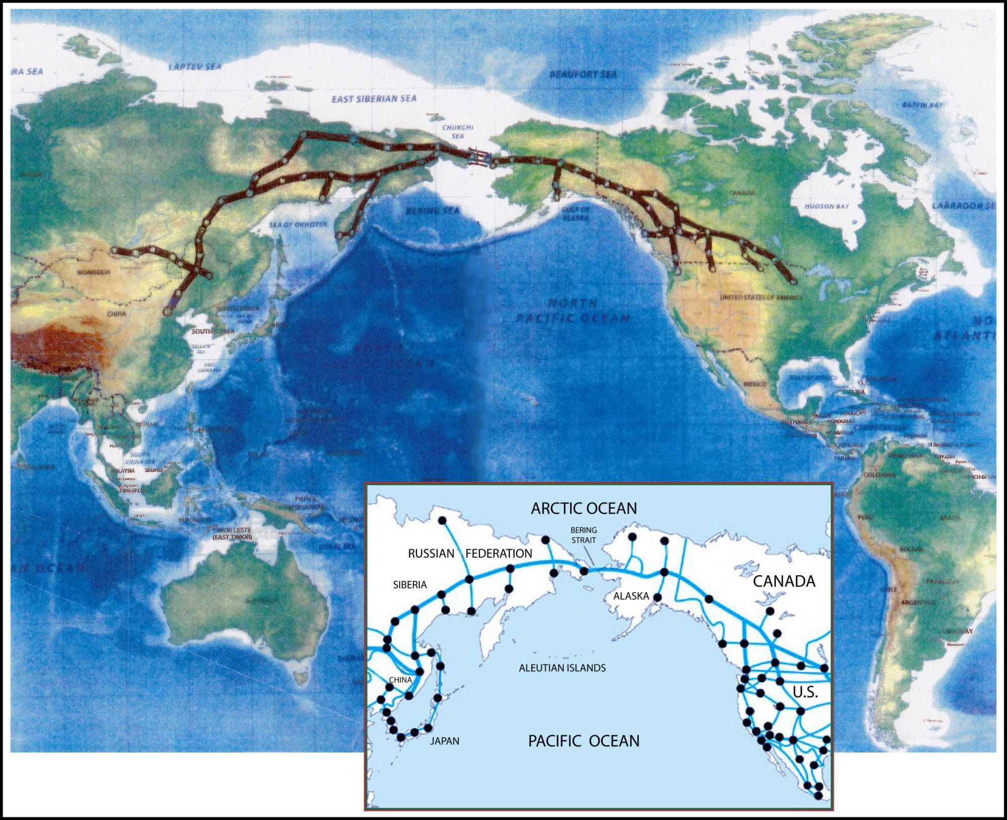
Euroasia-America rail link via Bering Strait tunnel

Map of proposed and existing rail networks across Eurasia and North America, connected by a Bering Strait tunnel (original edition).
Euroasia-America rail link via Bering Strait tunnel

Map of proposed and existing rail networks across Eurasia and North America, connected by a Bering Strait tunnel (2025 revised edition).
Bering Strait Tunnel Cross-Section via the Diomede Islands
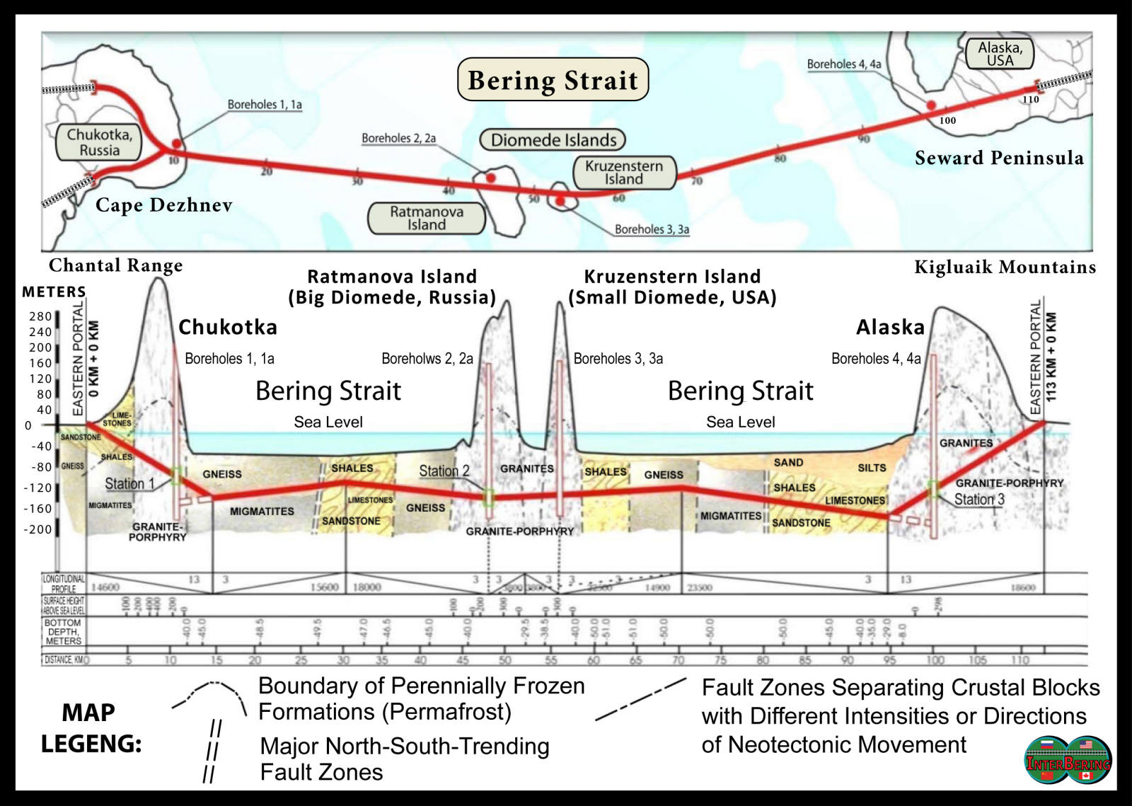
Bering Strait Tunnel cross-section concept showing a proposed rail tunnel alignment between Chukotka, the Diomede Islands, and Alaska, with geological layers and station locations.
Regional corridor map outlining the proposed Alaska–Canada Rail Link
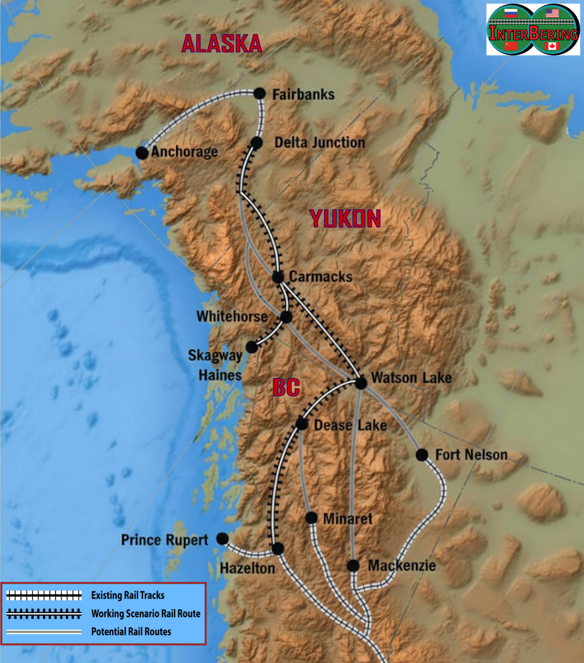
Area map of the proposed Alaska–Canada Rail Link corridor developed during Phase 1 (2005–2007) of the formal feasibility study . The diagram illustrates potential route alignments extending from the Alaska Railroad system southward into Yukon and northern British Columbia, where the corridor would integrate with Canada’s national rail infrastructure. Major geographic features, transportation corridors, and regional connections are shown to evaluate engineering feasibility, economic viability, and strategic integration with North American freight networks. This study phase represented one of the first structured assessments of a continuous rail link between Alaska and the continental rail system. The present version of the map is based on the 2005–2007 feasibility studies and was redesigned by InterBering in 2026 to include an additional Anchorage–Tok rail link connection.
Alaska-Canada Rail Link to Eurasia

Proposed Bering Strait / Alaska–Canada Rail Connector to the Lower 48 States, illustrating a conceptual extension of North American rail infrastructure toward an intercontinental link with Eurasia. This earlier version was designed by Dr. Hal Cooper, Jr., PhD, PE, consulting engineer at Cooper Consulting Co., Kirkland, Washington, and first presented at the Schiller Institute Conference, September 15–16, 2007 , in Kiedrich, Germany.
Alaska Railroad
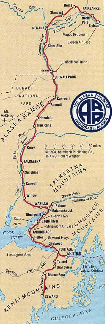
Map of the Alaska Railroad showing its main line from Seward to Fairbanks.
Satellite photo of the Bering Strait
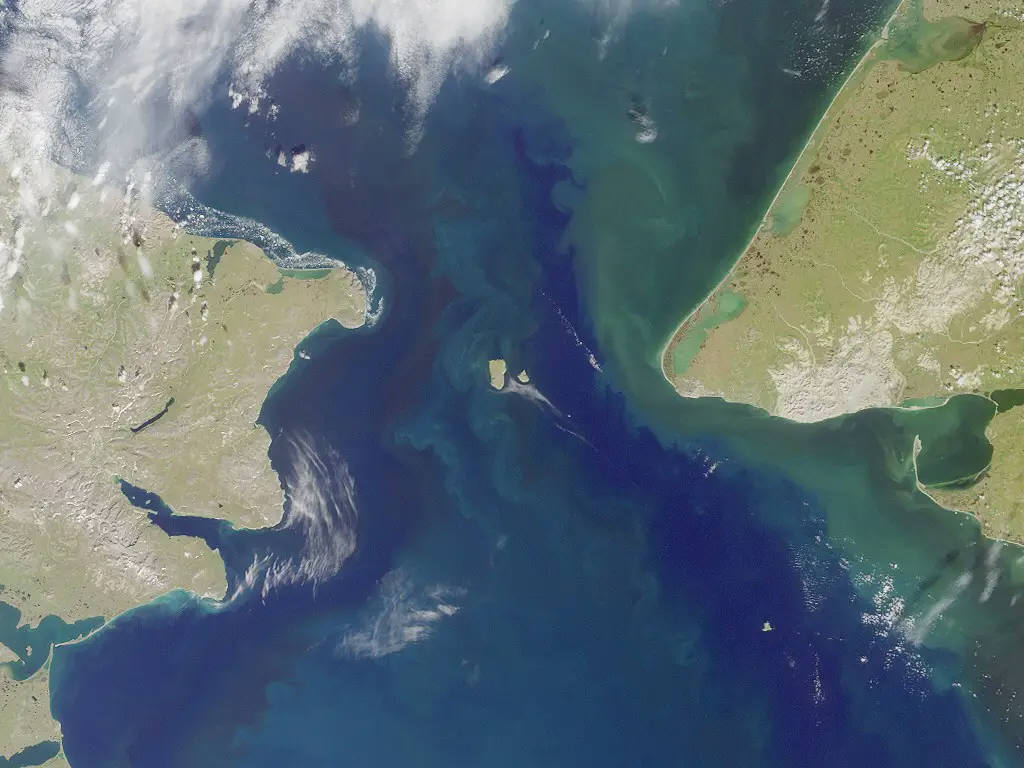
Satellite image of the Bering Strait showing the waterway between USA and Russia, including the Diomede Islands at the center.
US NOAA nautical chart of Bering Strait
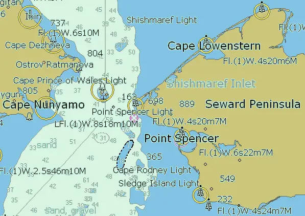
U.S. NOAA nautical chart of the Bering Strait showing navigation routes, depth soundings, coastal features, and the Diomede Islands between Alaska and Chukotka.
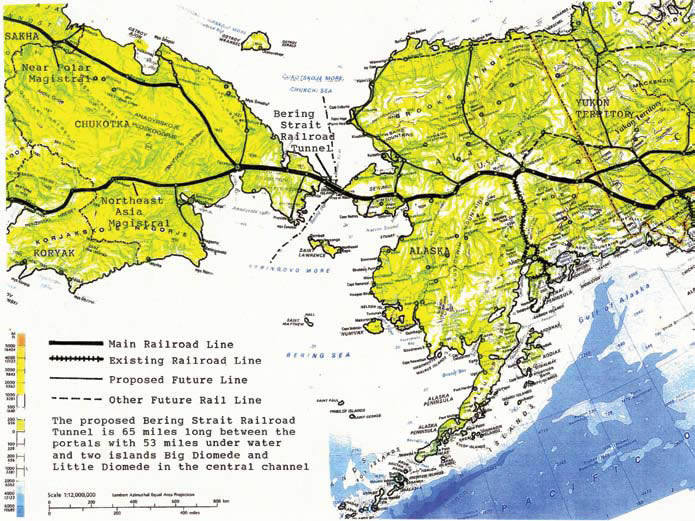
Bering Tunnel Route between USA & Russia
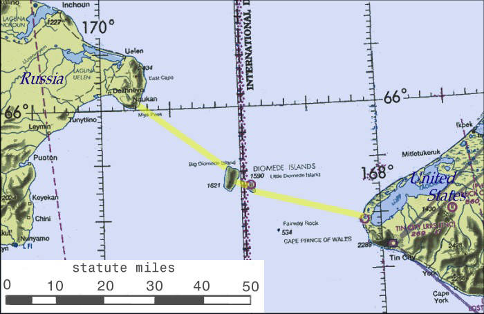
Map of the proposed Bering Strait tunnel route linking Chukotka (Russia) and Alaska (USA) via the two Diomede Islands, separated by the International Date Line.
Diomede Islands (Bering Strait)
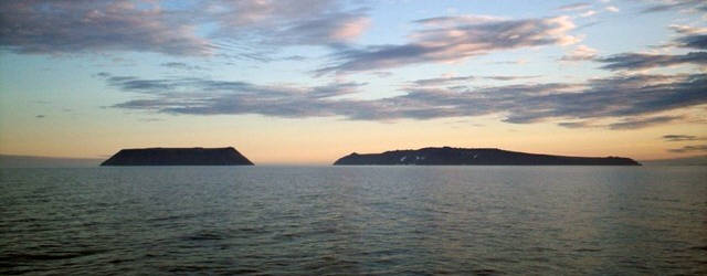
Photograph of the Diomede Islands in the Bering Strait: Little Diomede Island (Kruzenstern Island), Alaska, USA (left), and Big Diomede Island (Ratmanov Island), Chukotka, Russia (right), separated by approximately 3.8 kilometers (2.4 miles). The image was taken from the north from the waters of the Chukchi Sea. Photo credit: Dave Cohoe.
Diomede Islands Satellite Photo
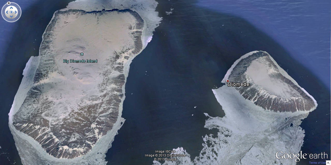
Google satellite image of the Diomede Islands in the Bering Strait: Big Diomede Island (Ratmanov Island), Russia (left), and Little Diomede Island (Kruzenstern Island), USA (right). Other satellite photos, including views with a possible tunnel route, are available at this page.
Big Diomede Island (Ratmanova Island), Chukotka, Russia
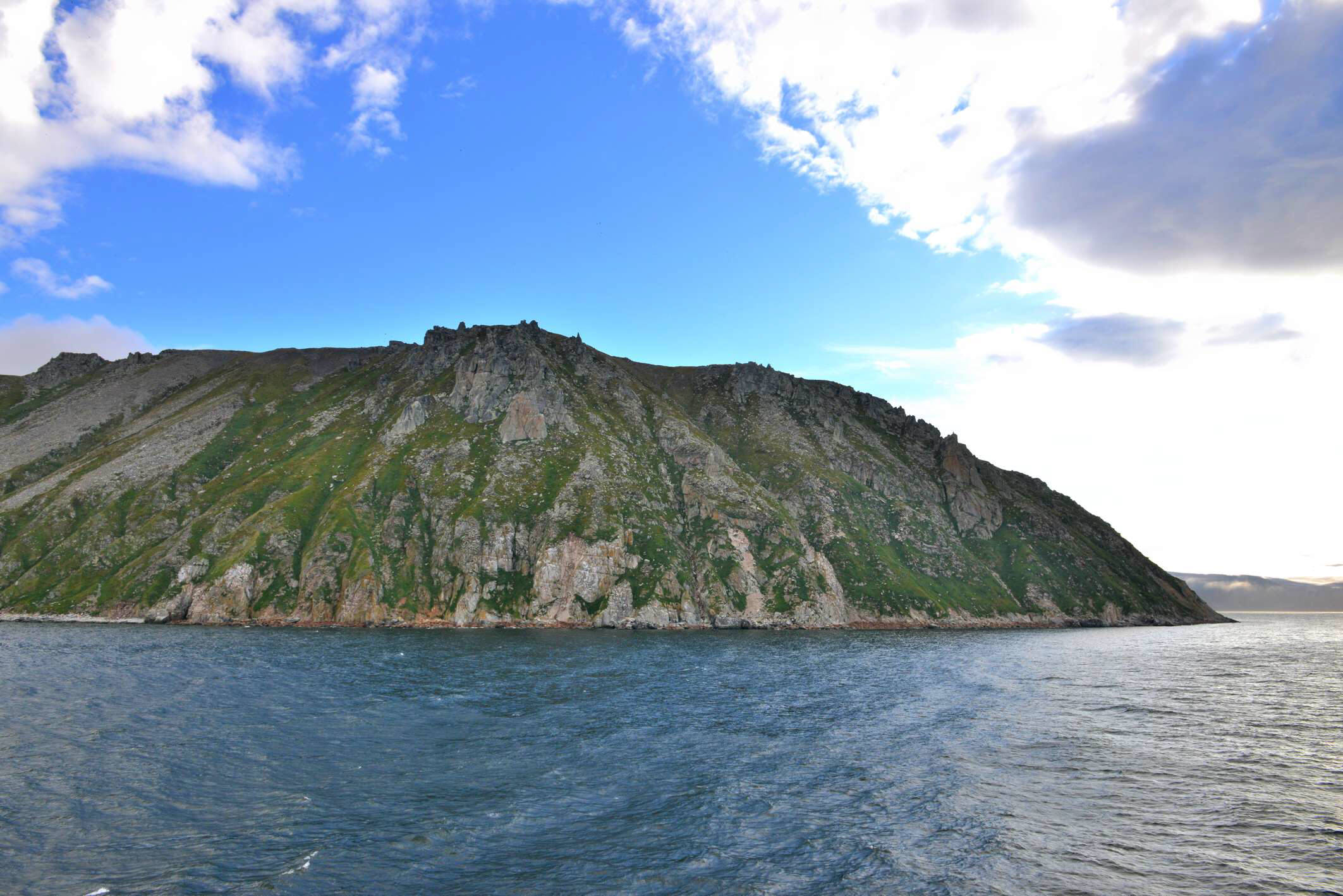
Photograph of the coastal landscape of Big Diomede Island (Ratmanova Island), territory of Chukotka, Russia, showing rugged shorelines and Arctic terrain. Photo by Ansgar Walk, 2014.
Little Diomede Island (Krusenstern Island), Alaska, USA
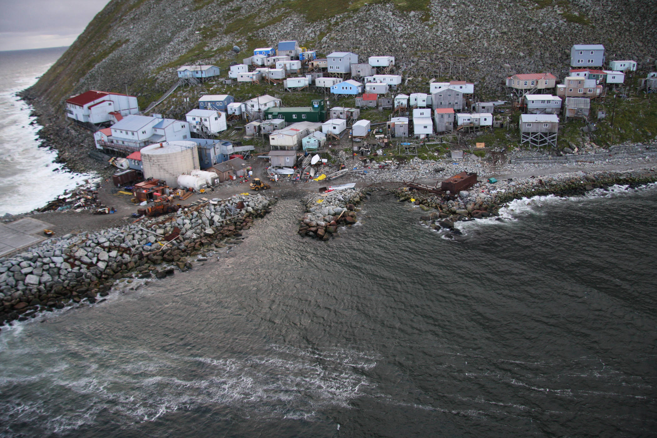
Photograph of the native village on the coast of Little Diomede Island (Krusenstern Island), Alaska, USA, showing coastal settlement and Arctic landscape. Photo by the United States Coast Guard, 2008.
Bering Strait Dam project by Soviet engineer
Petr Mikhailovich Borisov (Пётр Михайлович Борисов), 1957
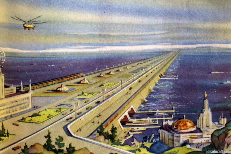
 Illustration of the proposed Bering Strait Dam project by Soviet engineer Petr Mikhailovich Borisov (Пётр Михайлович Борисов), a Stalin Prize laureate, envisioning a massive dam across the Bering Strait designed to alter Arctic climate through pumps mounted on prefabricated pontoons that would redirect cold and warm ocean currents. In addition to its climate-modification objectives, the structure would physically connect the coasts of Russia and the United States, creating a direct transcontinental land link between Eurasia and North America. In 1957, Borisov registered this concept under the title “Fundamental Improvement of the Climate of the Polar and Temperate Zones of the Earth” («Коренное улучшение климата полярных и умеренных широт земного шара») with the Committee for Inventions and Discoveries under the USSR Council of Ministers.
An English-language translation of the original 1960 Russian newspaper article describing this proposal—distributed by the Office of Technical Services, U.S. Department of Commerce, under the U.S. Joint Publications Research Service (JPRS)—can be viewed at Bering Strait Dam project translation (JPRS distribution). A related analysis published in the Anchorage Daily News, “Could a massive dam between Alaska and Russia save the Arctic?” by Jill Burke (November 26, 2010), is available at Anchorage Daily News article on the Bering Strait dam concept.
North Pole View to the Projected Railroads in the Northern Hemisphere
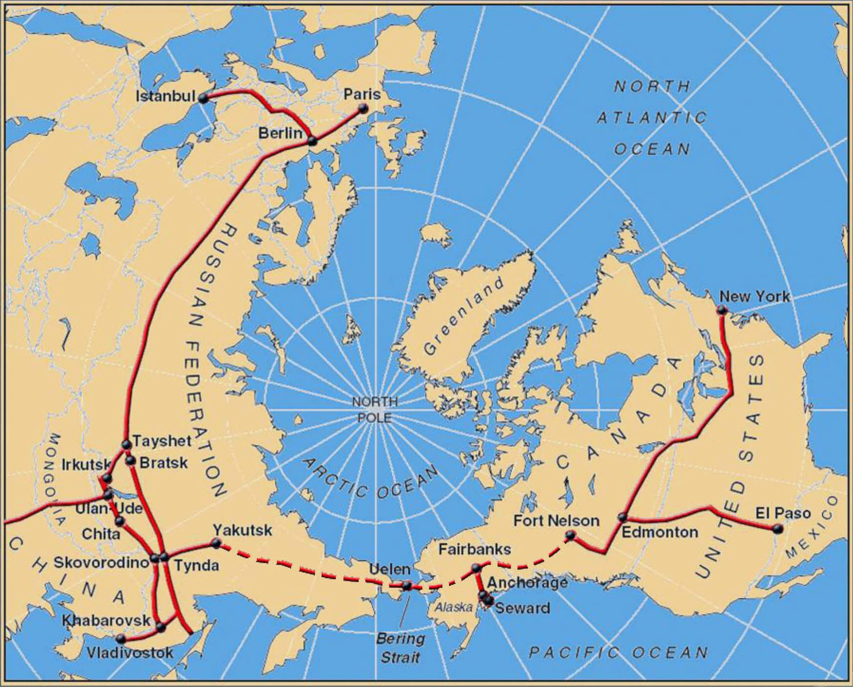
North Pole perspective map depicting existing and projected railroad networks throughout the Northern Hemisphere, emphasizing visionary trans–Arctic and intercontinental rail corridors linking Eurasia and North America.
Map of Chukotka, Russia (Chukotskiy Poluostrov)

Map of Chukotka, Russia (Chukotskiy Poluostrov), showing major settlements, topography, and regional transportation corridors in the northeasternmost region of the Russian Far East. Chukotka covers approximately 737,700 square kilometers (284,600 square miles). The full-size version of the map can be viewed at this page.
Map of Alaska, USA

Detailed map of the State of Alaska, USA, showing geographic features, major cities, and transportation routes. Alaska covers approximately 1,723,337 square kilometers (665,384 square miles). The full-size version of the map can be viewed at this page.
Yakutsk–Bering Strait–Alaska High-Speed Rail

Map illustrating a proposed high-speed railroad route from Yakutsk, Russia, to North America via a tunnel beneath the Bering Strait. On the Russian side, this alignment represents the Southern version of the Yakutsk–Bering Strait corridor, extending via Eldikan, Magadan, Anadyr, and Ozyorny before reaching the strait. After crossing into Alaska near Wales, the route continues through Nome, Koyuk, Nikolai, Willow (intersection with the Alaska Railroad), Palmer, and Glennallen, connecting onward to Canada through Whitehorse and south to the contiguous United States. A full presentation of this route can be viewed at this page.
North America physical map
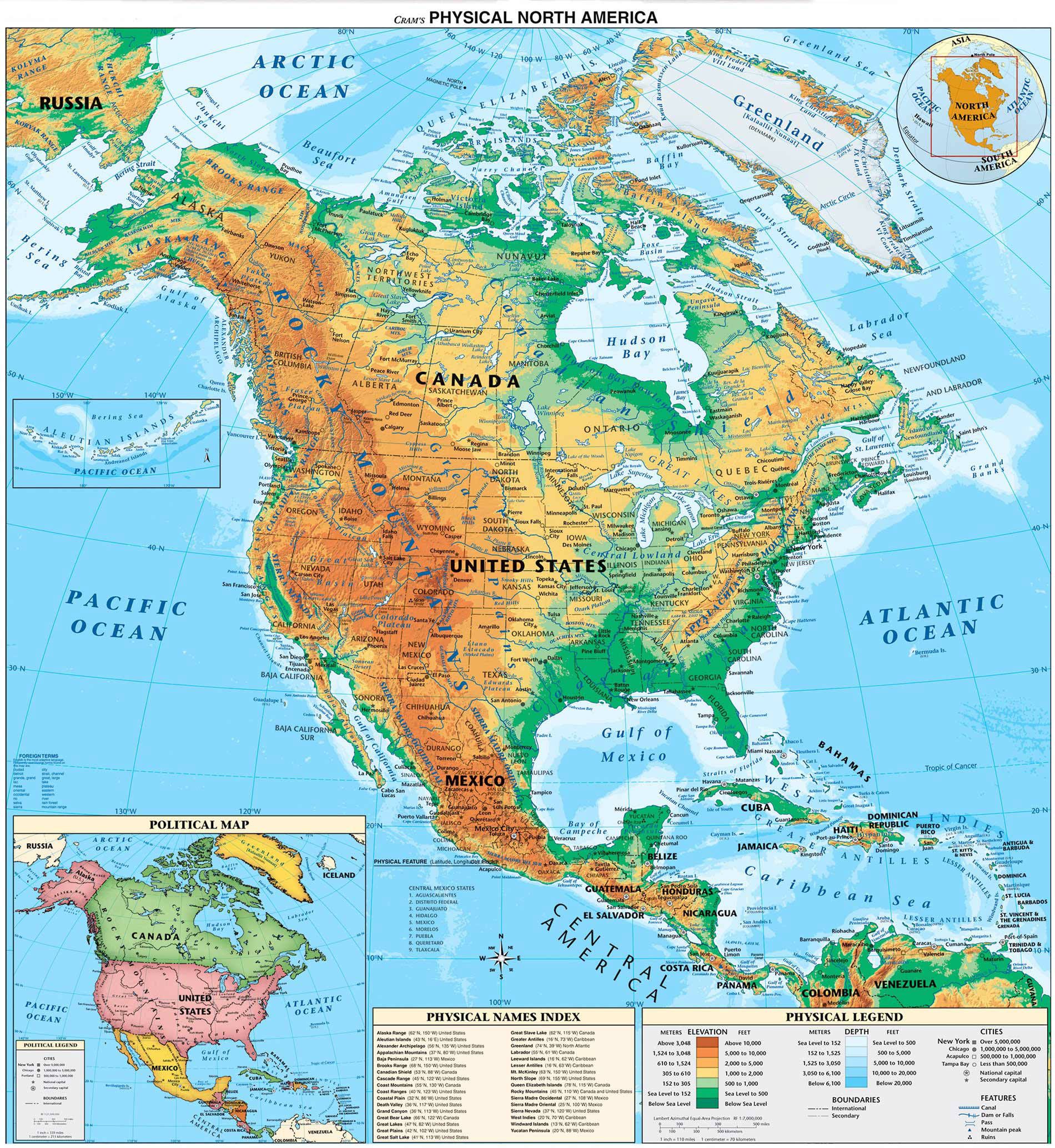
Physical map of North America illustrating major mountain ranges, river systems, plains, deserts, and coastal features. The map highlights key regions including the Rocky Mountains, Appalachian Mountains, Sierra Madre ranges, and the Alaska Range, along with the Great Plains and Interior lowlands. Major rivers—including the Mississippi, Mackenzie, Yukon, Colorado, and Rio Grande—are shown in relation to terrain. Arctic tundra regions, southwestern deserts, and coastlines along the Arctic, Atlantic, and Pacific Oceans are depicted. Elevation shading provides context for continental-scale topography and transportation planning across Canada, the United States, Mexico, and Greenland.
Preliminary Proposal – Bering Strait Tunnel & Silk Road Railway Connection

Map from the preliminary project proposal for the Bering Strait Tunnel and Silk Road railway connection extending the China One Belt One Road railroad corridor from Eurasia into North America through Canada and the United States. The proposal was prepared by Hal B. H. Cooper, Jr., PhD, PE, Consulting Engineer, CP&Y Incorporated — Kirkland, Washington, dated March 31, 2016. The full proposal document can be viewed at this link.
Silk Road Railroad Extension – China-Russia Intercontinental Route to the Bering Strait
Map illustrating the proposed route of the One Belt One Road extension of the Silk Road Railroad corridor through northeastern China and via Russia toward the Bering Strait Tunnel. Prepared by Hal B. H. Cooper, Jr., PhD, PE, Consulting Engineer, CP&Y Incorporated — Kirkland, Washington, dated March 31, 2016. The full proposal document can be viewed at this link.
Russia Transcontinental Mainline – Routes, Hydropower & Mineral Deposits
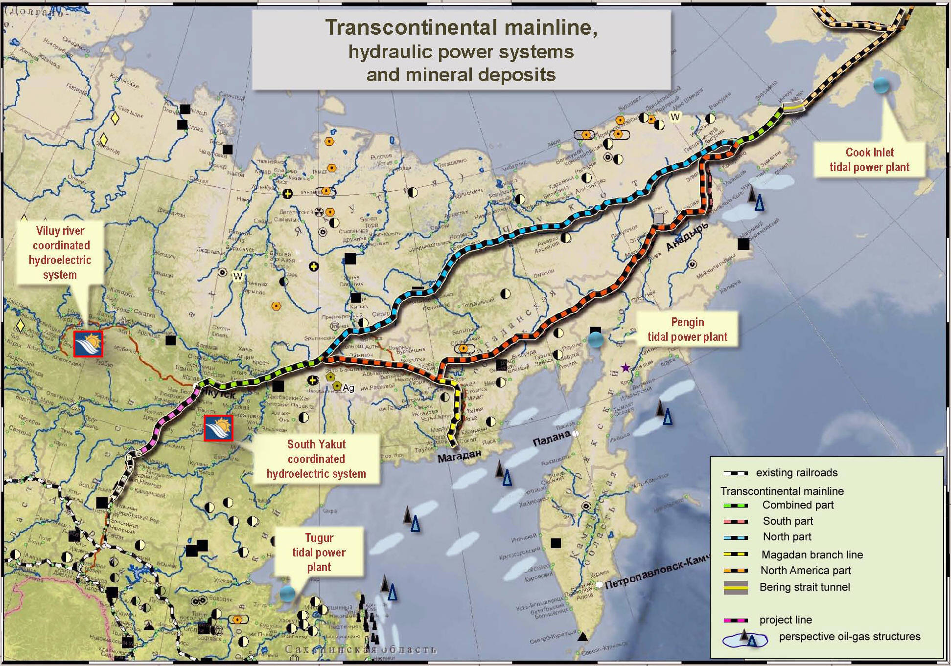
Map proposal showing two alignments (southern and northern routes) of a Russian Transcontinental Mainline, with related hydraulic power systems and major mineral deposit regions. Presented by Victor Nikolaevich Razbegin, Deputy Head and Deputy Chairman of the Council for the Study of Productive Forces of the Russian Federation, at the International Conference “Intercontinental Magistral Eurasia – America,” Yakutsk, Russia, August 17–19, 2011. More details are available at this page.
One Belt One Road Extension to Bering Strait
Map showing the proposed route of the One Belt One Road extension of the Silk Road railroad corridor toward the Bering Strait Tunnel area near Chukotka (Russia) and Alaska (United States), prepared by Hal B. H. Cooper, Jr., PhD, PE, Consulting Engineer, CP&Y Incorporated — Kirkland, Washington, dated March 31, 2016. The full proposal document can be viewed at this link.
Proposed Silk Road Extension to Bering Strait
Map depicting the proposed route of the One Belt One Road extension of the Silk Road railroad corridor from China through Russia toward the Bering Strait Tunnel and onward to Canada and the United States, prepared by Hal B. H. Cooper, Jr., PhD, PE, Consulting Engineer, CP&Y Incorporated — Kirkland, Washington, for the March 31, 2016 presentation to Ms. Diana Wu, Director of the North America China Council. The full proposal document is available at this link.
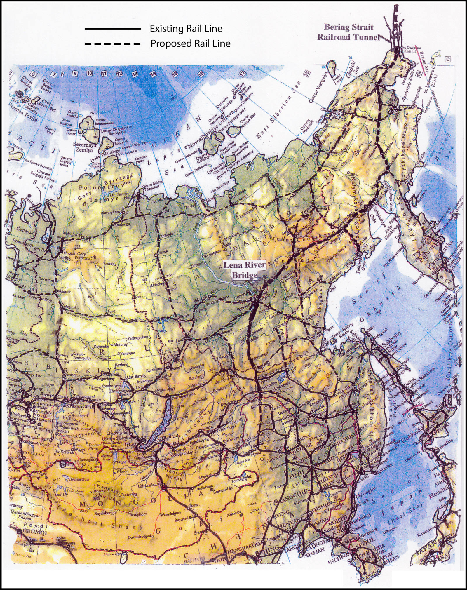
Russian Railroads XXI Century – Current and Future Network

Map showing the long-term topology of the Russian railway network in the first half of the 21st century, depicting all current railroads and planned future routes with distances between major stations and cities in kilometers. All information and annotations on the map are presented in the Russian language. The map was published with data reflecting conditions up to or before 2006 and therefore does not account for subsequent developments, including the completed railway connection from Berkakit to Nizhny Bestyakh across the Lena River from Yakutsk. The opening of this railway link, officially connecting Yakutia to the main Russian rail network, was marked on November 15, 2011 by Dmitry Medvedev, President of Russia, as described at this page. The full-size version of this map can be viewed on the screen at this page.

Bering Strait Railway Tunnel at Wales, AK
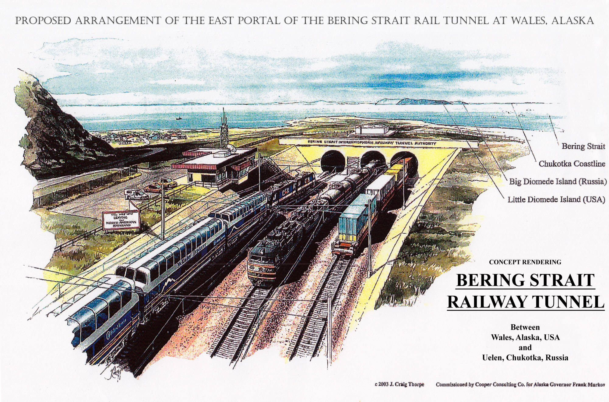
Concept rendering showing the proposed arrangement of the east portal of the Bering Strait Rail Tunnel at Wales, Alaska, created in 2003 by artist J. Craig Thorpe. The painting was commissioned by Cooper Consulting Co. for the Governor of Alaska, Frank Murkowski. The illustration depicts the tunnel portal structures, surrounding coastal terrain, and conceptual rail approach works on the Alaska side of the proposed intercontinental tunnel.
Alaska-Canada Rail Corridor near Lake Kluane, Yukon
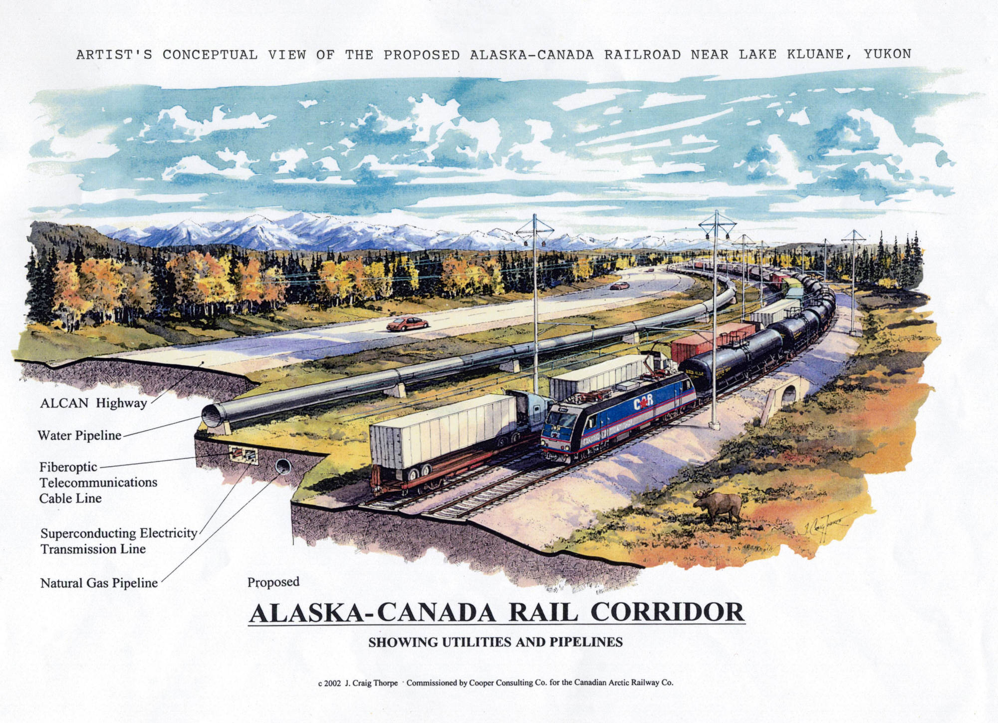
Conceptual view of the proposed Alaska-Canada Railroad near Lake Kluane, Yukon, showing the alignment of the rail corridor alongside utilities and pipelines. This 2002 concept rendering was created by artist J. Craig Thorpe and commissioned by Cooper Consulting Co. for the Canadian Arctic Railway Co.
Cascade Foothills Corridor freight railroad bypass line near Mt. Vernon, WA
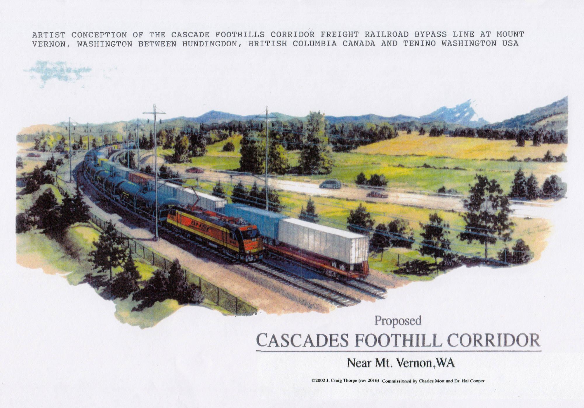
Conceptual rendering showing the proposed Cascade Foothills Corridor freight railroad bypass line at Mount Vernon, Washington, between Huntingdon, British Columbia, Canada, and Tenino, Washington, USA. The 2002 painting was created by artist J. Craig Thorpe and commissioned by Charles Mott and Cooper Consulting Co.
Lena River rail-road-utility bridge in the Sakha Republic (Yakutia, Russia)
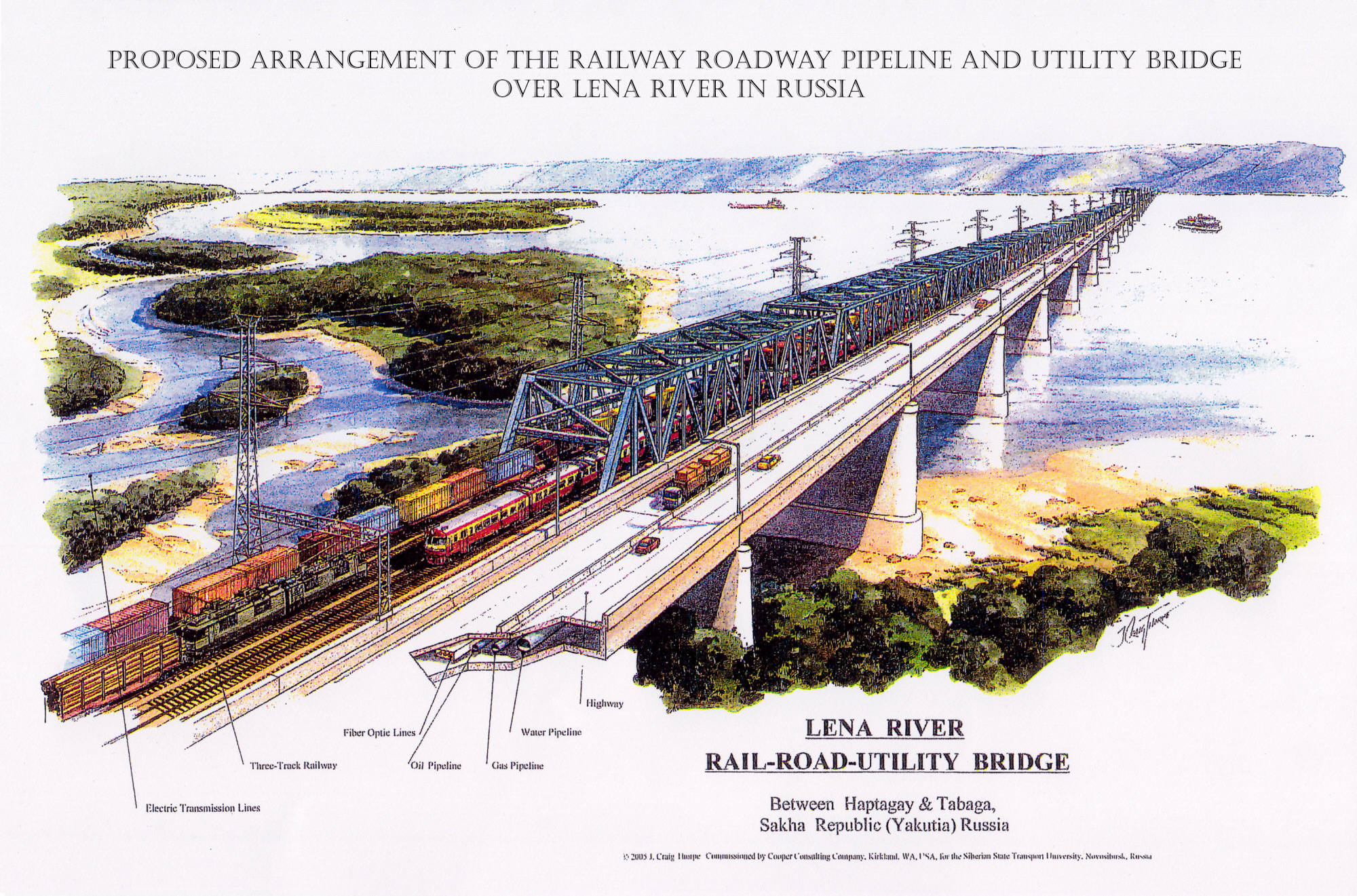
Concept rendering showing the proposed arrangement of a combined railway, roadway, pipeline, and utility bridge over the Lena River between Haptagay and Tabaga in the Sakha Republic (Yakutia), Russia. The 2005 painting was created by artist J. Craig Thorpe and commissioned by the Siberian State Transport University, Novosibirsk, Russia. The bridge is currently under construction by VIS Group, with projected completion in 2028.
Northern Tier high-speed rail Corridor near South Heart in Belfield, North Dakota
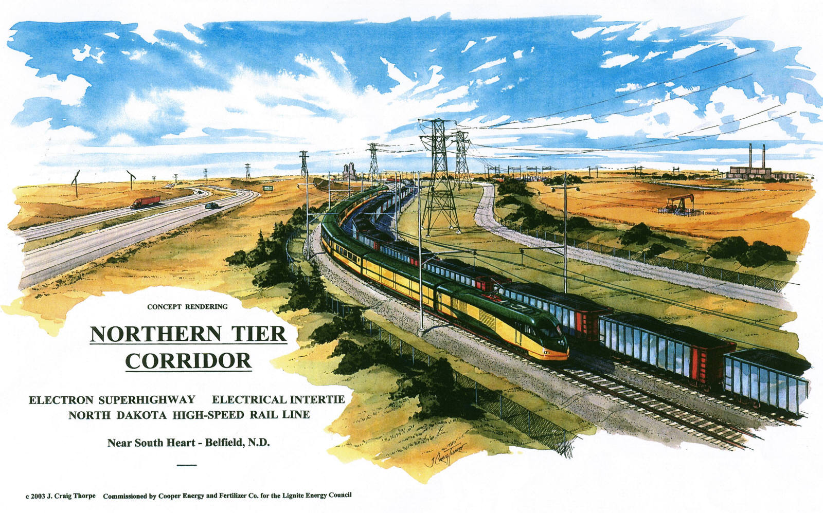
Concept rendering showing the Northern Tier Corridor electron superhighway electrical intertie and high-speed rail line near South Heart in Belfield, North Dakota, by artist J. Craig Thorpe in 2003. The painting was commissioned by Cooper Energy and Fertilizer Co. for the Lignite Energy Council and depicts proposed infrastructure integration of electric transmission and high-speed rail in the region.
California high speed rail transportation ground corridor
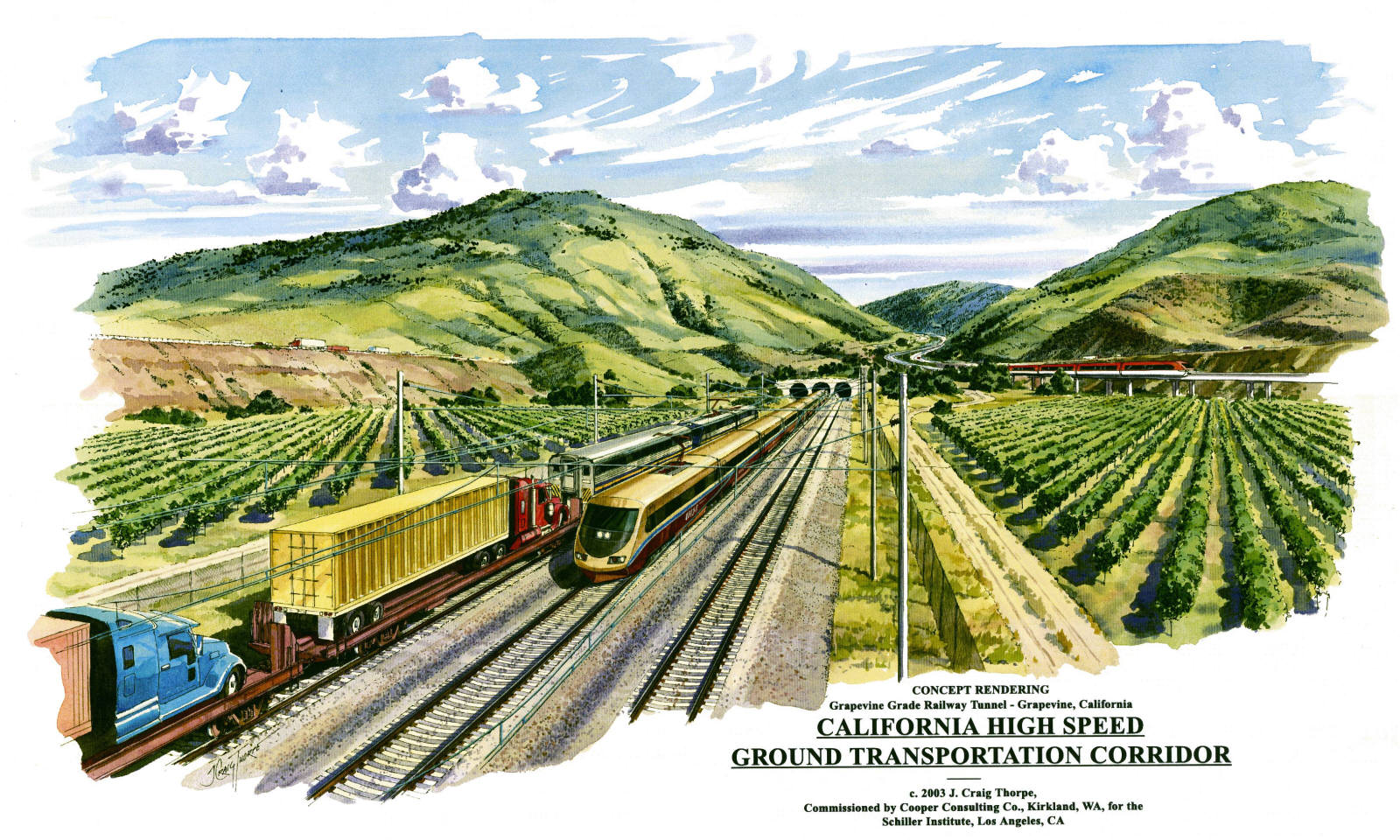
Concept rendering showing the Northern California high-speed ground transportation corridor and electron superhighway electrical intertie at the Grapevine Grade railway tunnel near Grapevine, California, created by artist J. Craig Thorpe in 2003. The painting was commissioned by Cooper Consulting Co., Kirkland, WA, for the Schiller Institute, Los Angeles, CA. This conceptual view predates the current California high-speed rail project, which is now under construction by The California High-Speed Rail Authority; see hsr.ca.gov for details.