
Interactive Map of the Ongoing and Proposed China-USA Intercontinental Railway via the Bering Strait
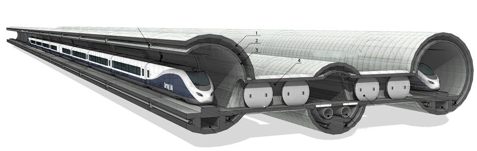
This page serves as a living infrastructure map for the InterBering corridor concept. It illustrates a proposed high-speed railway linking northeastern China with New York, crossing eastern Russia, the Bering Strait, Alaska, Canada, and the northern United States.
Estimated total length of the illustrated corridor: approximately 11,945 km (7,422 miles), following the route points currently shown on this conceptual InterBering map from Harbin to New York.
Click city markers to open short development notes, image cards, and links to related stories. Tunnel portal symbols indicate the proposed fixed-link crossing between Asia and North America.
How to Use This Page
The Harbin–Yichun High-Speed Railway represents the northernmost extension of China’s high-speed rail network and a potential gateway toward future Eurasia–North America rail integration.
This map focuses on a single proposed intercontinental alignment, without displaying competing routes, existing rail lines, or unrelated cities. The corridor begins at Harbin in China and first continues to Yichun. This approximately 300-kilometre (190 mi) high-speed railway segment (Harbin–Yichun High-Speed Railway) is currently under construction, with completion expected by the end of 2026 (source). As the northern extension of China’s national high-speed rail network within the Beijing–Harbin corridor, this line represents the most advanced approach of modern HSR infrastructure toward the Russian Far East.
The completion of the Harbin–Yichun High-Speed Railway will significantly strengthen regional connectivity in Northeast China by reducing travel time between Harbin and Yichun to approximately 1 hour and 40 minutes and integrating intermediate cities such as Suihua, Qing’an, and Tieli into the broader economic sphere of Heilongjiang Province. At the national level, the project fills a critical northern segment of China’s “Eight Vertical and Eight Horizontal” high-speed rail network, extending modern rail coverage into frigid regions and reinforcing the long-term revitalization strategy of Northeast China. From an international perspective, Yichun stands as one of the northernmost developed rail endpoints in China, positioned relatively close to the Amur River corridor and the Russian border, and is increasingly viewed as a potential gateway for future cross-border railway connections.
Within the context of the InterBering concept, this northern extension acquires additional strategic meaning. Once the development of an intercontinental corridor toward North America is further advanced, the route could continue from northeastern China across the Russian Far East toward Chukotka, proceed across the Bering Strait near Uelen, the Diomede Islands, and Wales, and then extend through Alaska, the Yukon, Alberta, the Canadian Prairies, and the Great Lakes region before reaching New York. In this vision, the Harbin–Yichun segment represents not only a regional infrastructure project, but the initial stage of a potential transcontinental high-speed rail connection linking Eurasia and North America.
Each marker on this interactive map may contain a short project note, an image, and a link to a fuller story (constantly under development by InterBering). This allows the page to function as a long-term “living map,” where new entries can be added as construction progresses or as additional research and proposals are developed along the corridor.
The map shows the shortest conceptual connections between major locations. For clarity, some lines may appear to cross water bodies (seas or lakes), although in reality a future railway alignment would normally route around them or use appropriate engineering solutions. The exact alignment could evolve after detailed engineering studies, environmental review, and consultation with authorities in China, Russia, the United States, and Canada, as well as with local landowners.
Interested landowners, communities, and regional authorities may also submit proposals suggesting how their cities or territories might connect to the corridor, whether through a direct route, a branch line, or by recommending adjustments to the alignment.
Route Points Shown
The alignment illustrated on this map begins in Harbin, China, continues through the Russian Far East, crosses the Bering Strait into Alaska, and then proceeds across Canada and the northern United States toward New York as part of the InterBering intercontinental railway concept.
The list of 61 locations shown below represents reference points used to draw the conceptual corridor on the map. Some of these names are major cities or regional transportation hubs that could serve as important junctions along a future railway. Others are smaller communities or geographic reference points whose known coordinates help define the approximate alignment of the route and guide it around coastlines, mountains, lakes, or other natural obstacles. Not every location listed here would necessarily become a station or settlement directly served by the railway; several are included primarily to illustrate the geographic path of the proposed corridor.
- Harbin
- Harbin North
- Hulan North
- Xinglongzhen West
- Suihua South
- Qing'an South
- Tieli
- Riyuexia
- Yichun West
- Wuying
- Hongxing
- Tangwanghe
- Wuyiling
- Kelinhecun
- Xunhezhen
- Sunwu
- Heihe
- Blagoveshchensk
- Belogorsk
- Fevralsk
- Ekimchan
- Chumikan
- Aimchan
- Okhotsk
- Magadan
- Merenga
- Anadyr
- Egvekinot
- Naukan
- Diomede
- Wales
- Brevig Mission
- Nome
- Koyuk
- Kaltag
- Nikolai
- Point MacKenzie
- Big Lake
- Houston
- Chickaloon
- Glacier View
- Nelchina
- Glennallen
- Gakona
- Chistochina
- Slana
- Beaver Creek
- Whitehorse
- Teslin
- Dawson Creek
- Grande Prairie
- Edmonton
- Regina
- Fargo
- Minneapolis
- Chicago
- East Chicago
- Gary
- Elyria
- Cleveland
- Warren
- New York